Sediment
- Reporting about sediment disasters in Cagayan River Basin, Philippines
- Sediment: some information about it
- In Magat River, a major infrastructure for irrigation and hydropower, bathymetric surveys showed that more than 30% reservoir trapping efficiency is reduction. Annual average sedimentation rate in the reservoir of 20 MCM/yr which is 5.5 times higher than the design. The rate of siltation in the live storage is 16.3 MCM/yr and 3.7m MCM/yr in the dead storage. Hence, it is expected that the power generation will cease most probably within 5 years without partial flushing implementation, while the irrigation service area will be reduced by 393 ha/yr
- Landslides (Cagayan Valley Regional Disaster Risk Reduction and Management Council, 2020)
- Typhoon Quinta (Oct 27, 2020)-series of landslides were reported along the National highway in Cagayan province particularly in the municipalities of Sta. Praxedes, Claveria and Sta Ana.
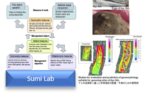
- NE Monsoon enhanced by Typhoon Vicky (Dec 18-20, 2020)-landslide incidents were reported in the provinces of Nueva Vizaya and Cagayan within the CRB with details below.
Figure16.1 - Tail-end of a cold front and Typhoon Ulysses (Nov 8-13, 2020)-there were 9 landslides across the region with details below
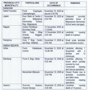
Figure16.2 - Tail-end of a frontal system and NE monsoon (Nov 28 - Dec 18, 2020)-2 landslides reported with details below
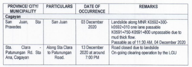
Figure16.3 - Typhoon Pepito (Oct 19-Oct 22, 2020)-there were 9 landslides reported in the region with details below
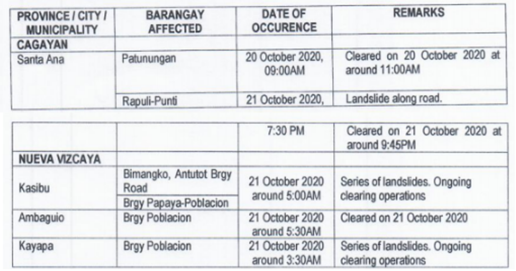
Figure16.4 Localized thunderstorm and SW monsoon (Oct 11-13, 2020) - Sta. Fe road in the Natioanl Hiway was unpassable due to landslide along with 3 local roads.
- Northeasterly surface windflow in the region (Oct 16-18, 2020) - 4 landslides were reported in Baggao, Cagayan with details below.
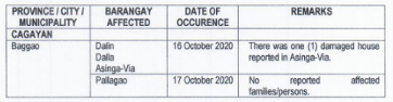
Figure16.5 - TD Ofel (Oct 13-15, 2020) - 1 person evacuated due to landslide threat
- Cagayan Isabela Nueva Vizcaya Quirino Batanes Total Aftermath of Typhoon Quinta (December 2020) Waist to Knee-deep level Number of Affected Brgys. 3 - - - - 3 Number of Affected Persons - - - - - - Number of Casualty - - - - - - Aftermath of the Northeasterly Surface Wind flow *1 parially damaged house Number of Affected Brgys. 4 - - - - 4 Number of Affected Persons - - - - - - Number of Casualty - - - - - - Tail-end of a cold front and Typhoon Ulysses (Nov 8-13, 2020) Number of Affected Brgys. 5 - 3 1 - 8 Number of Affected Persons - - - - - - Number of Casualty 4 - 10 - - 14 Tail-end of a frontal system and NE monsoon (Nov 28 - Dec 18, 2020) Number of Affected Brgys. 4 - - - - 4 Number of Affected Persons - - - - - - Number of Casualty - - - - - - NE Monsoon enhanced by Typhoon Vicky (Dec 18-20, 2020) Number of Affected Brgys. 1 - - 4 - 5 Number of Affected Persons - - - - - - Number of Casualty - - - - - -
- Sediment: some information about it
- Reporting about sediment disasters in Vu Gia-Thu Bon Basin, Vietnam
- Landside
In 2020, Quang Nam has 7 major landslides, 46 deaths.
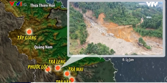
Figure16.6.Major landslides in Quang Nam, 2020 (source: VTV) 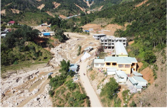
Figure 16.7: Landslide in Phuoc Thanh commune, Phuoc Son district, Quang Nam province, 2020 (source: http://baoquangnam.vn/) 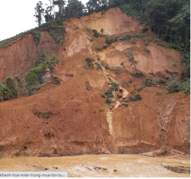
Figure 16.8. Landslide in Tay Giang district, Quang Nam province on October 28, 2020 (source: Tuoi Tre newspaper). - Erosions
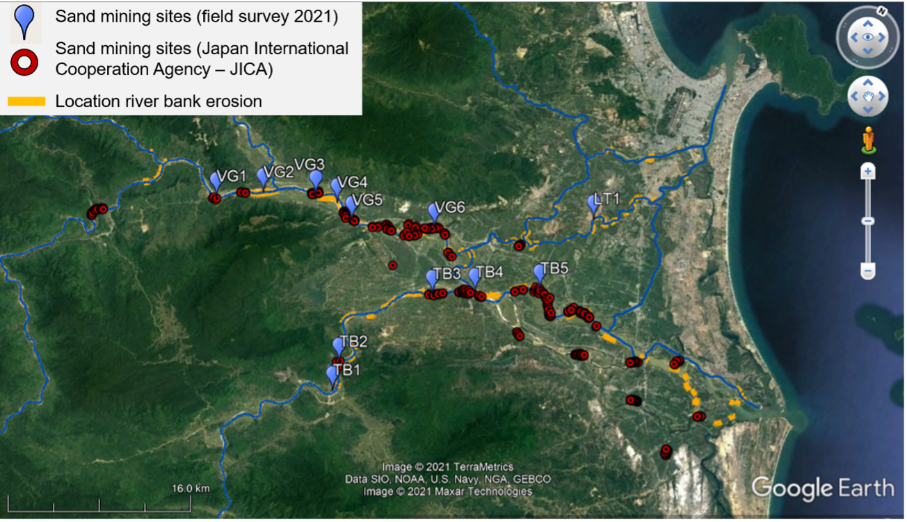
Figure 16.9: Bank erosion positions and lengths on the Vu Gia Thu Bon river (field survey, March 2021) Table 1: The erosion information at major erosion sites (field survey, March 2021)
No. River X Y Location Contents 1 ThuBon 15.866933 108.241967 Hoi An, Quang Nam - The right bank is strongly eroded, with a length of about 1200m
- The largest erosion width is about 150m, the average erosion width is about 80m
- Erosion height is about 2.4m
- Erosion shape: vertical slide
- The location of the strongest erosion has coordinates: 15.86302522, 108.23836718
- The left bank is slightly eroded
2 ThuBon 15.869333 108.170117 Dien Tho, Dien Ban, Quang Nam - At the location of the curved river and the location where sand is mining (6 machines are sucking sand)
- The left bank is eroding strongly and is continuing to erode
- The erosion length is 1600m, the erosion height is 2m - 5m.
- Right bank is eroding but stabilized
3 ThuBon 15.848107 108.140508 Dai Hoa, Dai Loc, Quang Nam Hạ lưu cầu Giao Thủy - Located at sand mining site (10 machines are exploiting sand)
- The left bank is strongly eroded, the erosion length is about 1110m.
- Erosion height 3.5m
- Sand mining leaves large gravel beds to emerge out of the water
- The right bank is an alluvial ground
4 ThuBon 15.824577 108.086903 Dai Thang, Dai Loc, Quang Nam - Both banks are moderately eroded
- Sand mining greatly changes the topography of the riverbed, some locations have large local depths
- Sand mining leaves large gravel beds to emerge out of the water, especially on the left bank
5 Quang Hue 15.845017 108.114154 Cửa ra sông Quang Hue giao với sông Thu Bon - o The right bank has a large erosion of about 360m, the erosion height increases gradually to the outlet from 1m - 5m, the erosion is vertical.
- The embankment works but has been damaged in part, the rest is damaged at the foot of the embankment
- The left bank is alluvial ground, near the sand mining site, so erosion areas appear
- The size of sand on the riverbed and on the banks of the Quang Hue river is larger than in the Thu Bon River
- The water of Quang Hue river is more turbid than Thu Bon river, at the intersection, it creates two distinctly different turbidity waters
6 Vu Gia 15.866729 108.062721 Dai Phong, Dai Loc, Quang Nam - There are 6 machines mining sand at the erosion site
- Both banks are eroded, the length of the erosion is about 920m, the height of erosion is 1m - 3m
- Greater erosion on the left bank
7 Vu Gia 15.848948 108.019589 Dai Quang, Dai Loc, Quang Nam - o There are 3 machines that are mining sand
- o Erosion on the right bank is about 200m in length, 0.5 - 1.5m in height
- o The roof embankment is damaged
8 Vu Gia 15.85551 107.98033 Dai Hong, Dai Loc, Quang Nam - There are 6 machines that are mining sand
- Erosion is very large on both sides, erosion is continuing
- The right bank is about 1600m long, about 3.5m high
- The left bank is about 370m long, about 1.5m high
9 Vu Gia 15.83466 107.933318 Dai Lanh, Dai Loc, Quang Nam - The right bank is very strongly eroded, the erosion length is about 2500m, the height is from 1m - 5.5m, the average width is 50m.
- The location of the strongest erosion is at coordinates 15.83449589, 107.93434381
- Many people's houses have been drifting down into the river, some houses inside are in danger of erosion, people have to move
- The left bank is slightly eroded, about 0.5m high
- Location of sand mining, leaving large gravel yards at the bottom of the river
10 Bung 15.821184 107.835974 Dai Son, Dai Loc, Quang Nam - The left bank at the position of the curved river section is strongly eroded, the erosion length is about 220m, the height is 4m
- The size of gravel on the bottom of the river is large, there is a large gravel beach emerging on the left bank
- The water is clearer than Vu Gia and Con Rivers
11 Lac Thanh 15.939786 108.181309 Dien Hoa, Dien Ban, Quang Nam - Left bank erosion (on railway bridge), erosion length about 550m, height 1m-3m
- Sand mining paused, due to major erosion
- On the left bank, there is a sand mining site
12 Qua Giang 15.970807 108.205385 Hoa Phuoc, Hoa Vang, Da Nang - The left bank is strongly eroded (above the Qua Giang bridge, the position of the river is curved) about 710m in length, about 0.5m - 2.5m in height.
- The right bank is heavily eroded with a length of about 300m, a height of 0.5m - 2m
- Vertical slip erosion
- Landside